Kuaternion
Let's measure your World
Self Control
SELF CONTROL
Sistema di monitoraggio gEomatico Lowcost Finalizzato al CONTROLlo delle strutture/infrastrutture
THE SYSTEM
SELF CONTROL project is aimed at increasing
the capability of controlling infrastructures and at the
improving the ability to identify phenomena that are going to
interfere with the infrastructure itself, by integrating Geo
Big Data and GNSS measurements, and monitoring infrastructures
(and critical phenomena that interfere with them)
plano-altimetric movements, speeds and accelerations.
The exceeding of established
displacement/velocity/acceleration thresholds will provide
signals of alert to prevent and control structural and
stability problems.
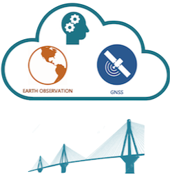
SELF CONTROL is based on the integration of some main modules,
that are:
* Earth Observation module
* GNSS module
* Cloud module
Earth Observation module
It consists of all the information acquired from satellite constellations that provide Geo Big Data (optical and SAR data). The information used and its resolution varies according to the needs of the infrastructure to be monitored, and it provides the possibility of generating high resolution digital terrain models (DTM), time series relating to movement and speed of the structure and/or terrain, land use maps and cartography.
GNSS module
It is composed of GNSS sensors monumented on segments of the
infrastructure to be monitored (portions of the infrastructure
where critical phenomena have been reported or identified).
The GNSS segment allows real-time control of the position,
displacement and speed of the monitored points in real-time or
near-real time, using the patented VADASE® approach.
Cloud module
It is composed of the Cloud platform on which all the
proprietary algorithms necessary for the management,
integration, processing and analysis of data are
implemented. The data collected by the sensors are
processed inside the Cloud module, whose computational engines
are:
- The SISAR software (High Resolution Satellite Image
Software). SISAR is a software for the extraction of 3D
high-resolution models from satellite images in which an image
matching algorithm that uses the image orientation models to
limit the search area of the corresponding primitives is
implemented, allowing fast and robust matching.
- The VADASE® proprietary algorithm (Variometric Approach for
Displacement Analysis Stand Alone Engine). The VADASE®
approach allows the use of low-cost single frequency receivers
for the evaluation of the displacements and the waveforms
typical of a high frequency event (earthquake), unlike the
systems of traditional monitoring using dual frequency
receivers, allowing to reduce the cost of a system order of
magnitude (from tens of thousands of euros to some hundreds).